Hurricane David's Brevard County impact, September 1979
David hit Titusville and Brevard as a downgraded tropical storm on September 3-4, 1979, after a Caribbean track that had killed thousands in the Dominican Republic. The Florida impact was severe but not catastrophic.
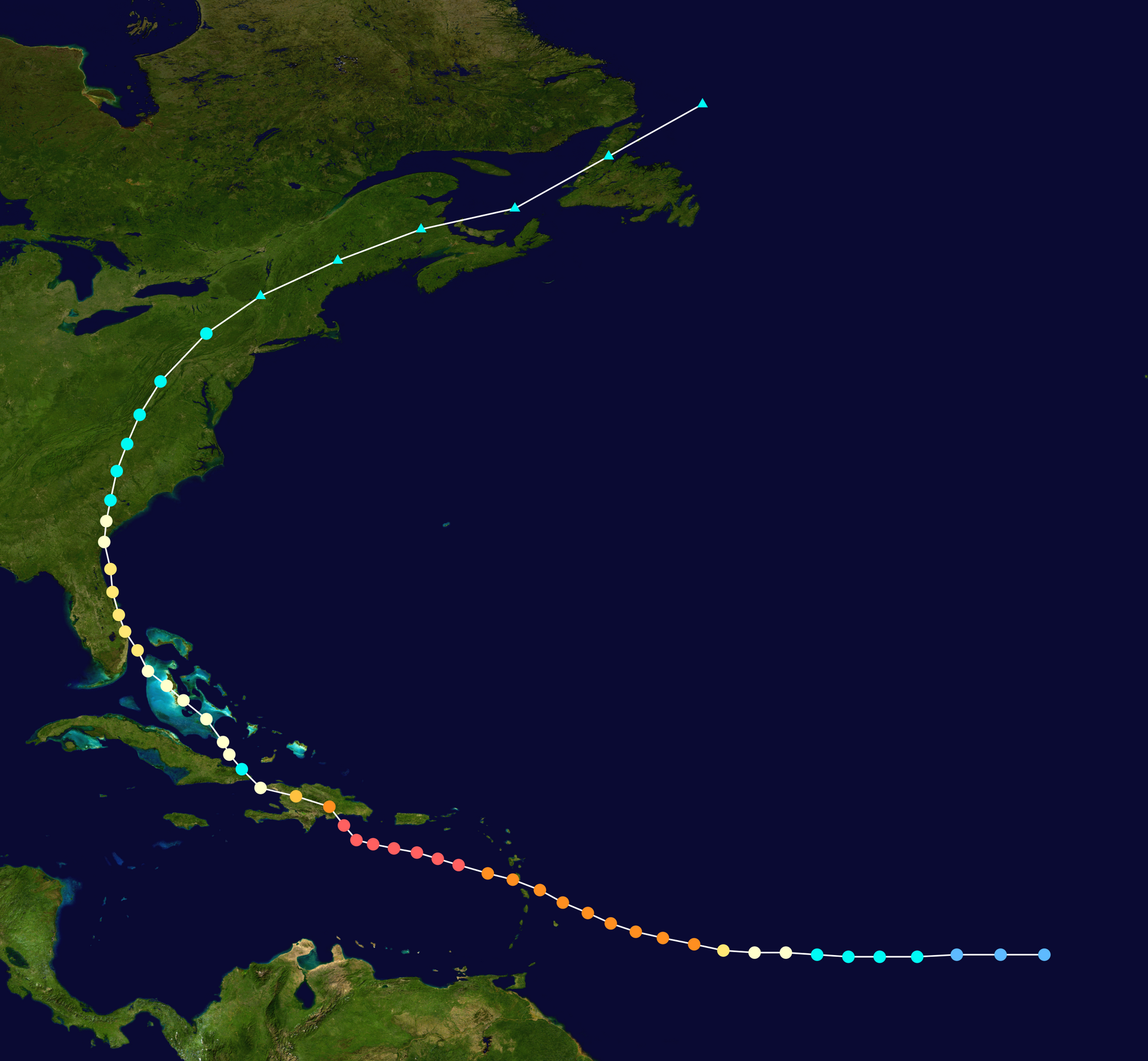
Hurricane David hit the Florida east coast on September 3, 1979, after a Caribbean track that had peaked as a Category 5 in the Dominican Republic (killing approximately 2,000 people there) and then weakened over Hispaniola and Cuba before re-strengthening modestly over the Gulf Stream. By Florida landfall the storm was a strong Category 2 (about 95 mph maximum sustained winds), tracking up the east coast roughly parallel to the shore. The center passed offshore of Brevard County early on September 4, 1979.
For Titusville the storm produced sustained tropical-storm-force winds, gusts to hurricane force, several inches of rainfall, and minor-to-moderate damage. It was not a catastrophic storm for Brevard. It was a serious storm. The distinction matters.

The track and intensity
David formed in the eastern Atlantic in late August 1979, rapidly intensified, and made landfall in Dominica as a Category 4 on August 29. The storm continued west, crossed the southern coast of the Dominican Republic on August 31 as a Category 5 (the strongest hurricane to strike Hispaniola in over fifty years), and produced catastrophic damage across the country. Approximately 2,000 deaths are attributed to David in the Dominican Republic, with additional deaths in Haiti and elsewhere in the Caribbean.
The storm weakened substantially over the mountains of Hispaniola. By the time it reached Cuba on September 1 it was a Category 1; over the Florida Straits it re-strengthened modestly to Category 2 strength. The Florida landfall was on the morning of September 3 near West Palm Beach.
The storm’s track took its center roughly parallel to the east coast and offshore for most of the Florida traverse. Coastal Brevard County, including Titusville, experienced the storm’s outer wind field and rainbands but not the eye. Maximum sustained winds at the Cape Canaveral instrumentation were in the 60–70 mph range with gusts approaching hurricane force.
What Brevard County experienced
The Titusville-area impacts on September 3–4, 1979 included:
- Sustained winds in the 50–60 mph range at peak, with higher gusts.
- Rainfall of 4–6 inches in Brevard, with some locations recording closer to 8 inches.
- Storm surge on the lagoon-side of perhaps 2–3 feet above normal, with some flooding of low-lying lagoon-front areas but no major catastrophic flooding.
- Power outages affecting most of the county for periods ranging from hours to several days for the worst-affected areas.
- Tree damage widespread, particularly to older oaks and to fast-growing species (Australian pines, Brazilian peppers) that were structurally vulnerable to high winds.
- Roof and siding damage to older buildings in the Titusville area, with most claims in the moderate range rather than catastrophic.
Several manufactured-home parks in unincorporated north Brevard suffered more severe damage than the city’s masonry-and-frame older housing stock. The pattern was the standard one for a Cat 2-equivalent storm: scattered serious damage rather than widespread destruction.
No fatalities in Brevard County were attributed to the storm. Several injuries were reported, primarily from falls during cleanup and from vehicle accidents during the storm period.
Comparison to other 20th-century storms
David’s Brevard impact was moderate compared to several other 20th-century storms:
- The 1928 Okeechobee hurricane (the Lake Okeechobee dike failure that killed over 2,500 people in Palm Beach County) produced limited direct impact on Brevard but was a defining regional weather event.
- Hurricane Donna in 1960 tracked through south Florida and central Florida with significant Brevard impacts; the storm coincided with the Apollo-era buildup and damaged some KSC construction infrastructure.
- Hurricane Erin in 1995 caused approximately $700 million in damage across central Florida including substantial Brevard impacts.
- Hurricane Floyd in 1999 prompted the largest evacuation in U.S. history at the time, with Brevard County under mandatory evacuation order; the storm eventually tracked offshore and Brevard’s actual impacts were limited.
- The 2004 hurricane season (Frances, Jeanne, and Wilma all tracking near Brevard) produced cumulative damage approaching $1 billion in the county.
- Hurricane Matthew in 2016 and Hurricane Irma in 2017 caused significant damage to lagoon-front infrastructure.
David in 1979 sits in the middle of that range. Significant enough to disrupt the county for a week, not severe enough to leave lasting infrastructure changes.

The civic response
Titusville’s emergency-response infrastructure in 1979 was substantially built up from the pre-Apollo town’s capacity. Brevard County’s emergency management office, the county sheriff’s office, the local police and fire departments, and the Florida Power and Light service infrastructure all responded effectively to the storm. Power was restored across most of the county within 72 hours; the worst-affected areas were back online within a week.
The Florida Today coverage from the period documents the standard storm-cleanup sequence: damage assessment Monday and Tuesday, debris removal beginning Wednesday, public services restored progressively through the week.
Why David matters for Brevard’s storm history
David was the first major hurricane impact on Brevard County in the post-Apollo era. The 1960s population spike had built out housing infrastructure that hadn’t been weather-tested at hurricane intensities. The 1970s storms (Camille in 1969 affected Brevard only at long distance) had not seriously tested the county’s hurricane-readiness as a major-population area.
David’s moderate Cat 2 impact provided a useful calibration. The major weaknesses identified, manufactured-housing vulnerability, drainage problems in low-lying lagoon-side areas, several specific infrastructure failures (a major substation outage that affected a large area for an extended period), were addressed in subsequent years through code updates and infrastructure investments.
By the time the major 2004 storm season hit, Brevard County’s infrastructure was substantially more storm-resilient than it had been in 1979. David is one of the data points that drove that improvement.
The Brevard tornadoes
The most specific verifiable damage from David in Brevard County came not from sustained winds but from tornadoes the storm spawned as its rainbands crossed the coast. Per the National Hurricane Center’s post-storm record, two tornadoes generated by David’s rainbands “caused damage to approximately 50 mobile homes and a shopping center in Melbourne Beach and Palm Bay,” with the shopping center damage alone totaling approximately $1.5 million in 1979 dollars (roughly $6 million in 2026 dollars). Additional tornado damage in Cocoa included roof damage to several structures.
That pattern, the most concentrated damage coming from spawned tornadoes rather than from the storm’s primary winds, is typical of hurricanes that pass offshore of the Brevard coast rather than making direct landfall. The county’s outer rainbands tend to produce localized severe-thunderstorm activity that can spin tornadoes faster than the National Weather Service can issue warnings. The Melbourne Beach and Palm Bay tornadoes were the most damaging single events of the David storm in Brevard, even though they affected only a small fraction of the county’s geographic area.
For Titusville, the absence of a spawned tornado meant the city’s damage profile was the more typical sustained-wind-and-rain pattern. Manufactured housing in the Mims and north-county areas took the largest single-class of damage, with several units destroyed and others sustaining major roof and structural damage. The masonry-and-frame housing stock in Titusville’s older neighborhoods generally held up well.
What’s verifiable from the 1979 record
NOAA’s Hurricane Center post-storm report on David is the authoritative documentary source. Florida Today’s September 1979 newspaper archives provide local color and damage assessment. The National Hurricane Center’s historical storm-tracks database (HURDAT2) provides the storm’s official intensity and track record.
For Titusville residents who lived through it, David is one of the memorable storms, disruptive enough to be the reference point for “the storm in ‘79” but not destructive enough to be a multi-decade community trauma. The county’s hurricane experience has steadily added storms to that reference set since.
Further Reading
As an Amazon Associate we earn from qualifying purchases.